")
A century ago, the Hebard Cypress company razed what was then considered a nuisance swamp in southeast Georgia of its pond cypress. Some 400 million feet of timber was removed in total, and all this after a canal was dredged to drain the swamp altogether. The former effort was abandoned after only 11 miles had been dug. The idea, of course, was to turn this inconvenient swath of wetlands real estate into timber farms and croplands.
Thankfully, it didn’t work out that way.
Today, the Okefenokee Swamp is the stuff of legend. The cypress trees have returned, and the area is among the wildest in the American Southeast. It’s a giant blackwater swamp consisting of some 394,000 acres of designated wilderness. And it is a wilderness. On any given day, alligators (about 15,000 of them) outnumber human visitors, and its patented tannic waters and marshy prairies provide refuge for everything ranging from endangered red cockaded woodpeckers to river otters to a healthy population of black bears. It was protected by executive order as the Okefenokee National Wildlife Refuge by President Franklin D. Roosevelt in 1936.
Ironically, it’s another executive action—this one by former president Donald J. Trump—that might be putting this treasured swath of American wildlands at risk. And it’s another extractive industry that stands to benefit 100 years after the swamp was first razed for its timber resources. This time, though, the threat is more complex and more nuanced, and it comes in the form of a sketchy plan to mine sand on the fringes for the refuge for titanium and zirconium.
Dark-water wonderland for anglers
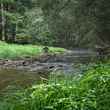
I pushed through the little channel carved among the moss-draped cypress trees, barely making a wake with the little 6-horse outboard attached to the stern of the aluminum skiff. It was my first visit to the swamp, and my head was on a swivel. I’d been in the backcountry for less than an hour, and if I’d seen one 10-foot alligator lurking in the grass along the channel, I’d seen a dozen.
For a Rocky Mountain trout angler, this was about as different as it gets. Now, I’m no stranger to wild country — I fish the backcountry of the Yellowstone region every summer and into the fall. But this was different. This was primal and, honestly, a little creepy. Home to the aforementioned gators, the swamp is also prime habitat for snakes, including the cottonmouth — a dusky black venomous serpent known for its random aggression at times — and a host of creepy crawlies I wanted absolutely nothing to do with.
I was, however, interested in the fish, but probably not the fish many people think of when they think about casting a line in southern Georgia.
The Okefenokee isn’t terribly famous for its piscine resources — the tannic acid-laced water makes for something of an austere environment for typically appreciated game fish in the region. Instead of bass, crappie and sunfish (like shellcrackers or bluegill), the swamp is home to lesser-known fish, like flyers, warmouth, chain pickerel, bullhead catfish and the powerful bowfin.
It was the latter that had captured my imagination from my home in Idaho, some 2,000 miles to the northwest. These prehistoric fish are likely older than the Cretaceous period gators with which they still share the swamp. The bowfin — also called a mudfish, dogfish, grinnel or swamp trout — is unique among the native fish of North America. Its range stretches from the swamps of the South to the backwaters of southern Ontario. Like its closest relative, the gar, it’s a “bimodal” breather — it can gulp air, an important adaptive quality for fish living in waters prone to low oxygen levels.
For anglers, though, the bowfin’s beauty comes in the form of its aggressive nature. It’s an ambush predator with a nasty disposition, and in the Okefenokee, it clearly rests atop the fishy food chain.
Advised by the proprietor in the gift shop at Stephen C. Foster State Park — one of a handful of entry points to the Okefenokee — I had acquired a dozen Yellow Sally flies. Not the Yellow Sally us trout anglers might use during a stonefly hatch, but something more closely resembling a bright yellow or chartreuse Wooly Bugger. And the locals wouldn’t necessarily call a Yellow Sally a “fly,” but it clearly meets the requirements as such. I’d also tied up a handful of weighted yellow Clousers and I’d crafted a few other yellow Slumpbusters. As you might suspect, in doing research prior to my visit, I was advised by one angler, “Any color will work as long as it’s yellow.”
It makes sense, I suppose. The water in the swamp, filtered through mats of decaying wood and leaf litter, is the color of strong coffee. For ambush predators, the first thing an angler needs to do is get its attention, and what better way to do that than with a gaudy, bright yellow fly.
The boats rented through Okefenokee Adventures (part of a private non-profit partnership) don’t have anchors, so it’s tough to just stop and cast. First, the swamp has a current, subtle though it may be. Think of the Okefenokee as a giant rain barrel with two spouts on the lip of the barrel on either side. One spout sends water down the famous Suwanee River, all the way through northwest Florida to the Gulf of Mexico. The other sends water down the St. Mary’s River to the Atlantic. So the water’s always moving.

Instead of anchoring, I’d seek out little “batteries” or “blowups.” These are little quaking islands of once-sunken peat (Okefenokee is a Choctaw word that translates into “land of trembling earth”) that rise to the surface thanks to the emission of methane and carbon dioxide created from the decomposition of all the plant matter that makes up the top layer of the swamp’s bottom. I’d gently nudge the little craft onto a battery and make a few casts.
The bowfin weren’t shy, and it didn’t take long before I connected with a foot-long fish that blasted out of the dark water and put on an aerial display that rivaled that of any bass or trout (or, frankly, tarpon) I’d tangled with in the past. Just like that, I was hooked. Bowfin, I determined then and there, would be my next addiction.
The prediction has held true. I returned to the swamp the following spring, and I pulled a bowfin out of the swamp that measured well over 30 inches in length. The addiction worsened. I’m now a hopeless bowfin junkie. I’ll go back for my next fix when the pandemic subsides, because the fish are worth the price and toil of cross-country travel. I’ve even toyed with the idea of seeking out a little Suwanee River fish camp where I could spend a few months each winter, away from the cold and gray of Idaho and among the “swamp trout” of the South.
It’s all in the sand
But the swamp and my beloved bowfin now face yet another existential threat from the “progress” of humankind. The sandy soil that lies beneath the peat that coats the bottom of the Okefenokee has the unfortunate luck to contain some fairly valuable heavy minerals, and one Alabama mining company — Twin Pines LLC — has a plan to go and get them.
And that plan got a little closer to becoming a reality thanks to the Trump administration’s rule change concerning Clean Water Act guidance — the Waters of the U.S. Rule that basically protected headwater streams and wetlands from development was basically thrown out. When the change went into effect in October 2020, about 400 acres of marshlands in the proposed 900-acre Phase One of the Twin Pines mining plan suddenly no longer fell under the purview of the federal regulatory process. This is important on two levels. First, many opponents of the mine crafted detailed comments to the U.S. Army Corps of Engineers (the sole permitting agency until October 2020) last spring regarding the mining process. Second, to mine titanium and zirconium — both are metal alloys used in everything from pipe fittings to jewelry — within just a few miles of the Okefenokee National Wildlife Refuge, Twin Pines will now only need to seek permits from the Georgia Environmental Protection Division and the environmental regulators employed by Charlton County. The comments from anti-mining interests are now largely moot and must be refined and resubmitted to the state and county.
To say the bar has been lowered is an understatement.
Sand mining for heavy minerals in the region is nothing new. A “ridge” of this mineral-rich sand stretches from Georgia south into Florida, and mining the sand ridge has been ongoing both north and south of the refuge for decades. But the Twin Pines proposal is for the sand ridge, formally called Trail Ridge, that’s situated right up against the southeastern boundary of the refuge. This makes it unique — remember the rain barrel analogy?
Trail ridge is essentially the lip of the barrel. Of all the water in the swamp, some 95 percent of it originates as rainfall. A full 80 percent of that rainfall evaporates into the atmosphere, leaving the remaining 20 percent of that rainfall to exit the swamp via the Suwanee River to the west and the St. Mary’s River to the east. Should something happen to the lip of the rain barrel, or if other holes are inadvertently punched into it, water leaving the swamp down the St. Mary’s River, which creates the Georgia-Florida border as it winds its way to the ocean, could be greatly diminished.

Is that really a concern? Well, the Twin Pines mining plan would have the company mining the sand some 50 feet below the elevation of the Okefenokee Swamp itself. At this depth, groundwater hydrology comes into play.
From the Georgia Conservancy’s comments, first submitted to the USACE in the spring of 2020:
“The application outlines a plan to excavate an average of 50 feet below the land surface, sort the material with a wet mill, and backfill in a 24-hour per day operation. The process exposes approximately 25-40 acres of ground per month. Much of the area near Trail Ridge possesses groundwater within two feet of the ground surface, and the site is no exception. Within the geohydrology study, a model for the existing Trail Ridge groundwater conditions, as well as changes to groundwater flow from mining operations lower the groundwater table, impacting Trail Ridge wetlands.”
Unfortunately, according to GC, the Twin Pines permit application is woefully short on details and relies on very small soil and water table sample sizes on which to base an entire mining operation.
“The application still lacks essential information from the applicant,” GC wrote in its comments to the USACE last spring. “The Okefenokee Swamp is a unique ecosystem and Trail Ridge is an integral component within it. Given that nearby mining could impose significant impacts on this ecological treasure, the Georgia Conservancy respectfully requests the development of a full Environmental Impact Statement (EIS) to assess cumulative impacts from all future phases of mining, over the entire Twin Pines-controlled property (12,000 acres).”
Twin Pines, on the other hand, heralds its processes as “cleaner” and “more environmentally friendly” than traditional “wet mining” technique that incorporates the use of a dredge and floating concentrator to get at the minerals.
It should be noted that Twin Pines entire mining process description consists of four paragraphs on its website — even a “myth vs. facts” section on the Twin Pines website makes uncited claims that aren’t even remotely backed up by even a hint of data or science. Some of the claims are just plain wrong — the notion that the company would be held to the strictest of Clean Water Act standards went out the window when the Trump administration ditched the Waters of the U.S. Rule last fall — this rule protected headwater streams and wetlands all over the country from unpermitted development. Perhaps the worries expressed by GC regarding the lack of salient mining details on the part of the company have merit.
The conservation group American Rivers thinks so. In 2020, the Okefenokee Swamp and the St. Mary’s River came in at No. 8 on the organization’s dubious list of most-endangered rivers.
The economics
Predictably, the company’s economic impact information it provides is a bit more robust than its skeletal outline of its mining methods. Consider this:
The total capital investment from Twin Pines into the regional economy will be $300 million, the company reports. At Charlton County’s existing 36.46 mill levy, that would come to a $4.375 million annual property tax contribution to county coffers. The project would employ 400 full-time workers, each earning an annual salary/benefits package worth about $60,000, the company says. This, the company claims, doesn’t count the “creation of many more employment opportunities in support industries such as transportation, fuel suppliers, industrial materials providers, and power production systems.”
Finally, the project’s lifespan could be up to 20 years, “which provides opportunities for long-term employment and extended financial benefits for the county and its citizens,” the company claims.
But the refuge itself, and the surrounding state parks and other public lands, present similarly enviable economic statistics, perhaps even moreso. According to the federal register in 2005, the 1999 economic impact of tourism in Charlton, Ware and Clinch counties in Georgia exceeded $67 million. That was when the refuge attracted 400,000 visitors a year. According to GC, today, “more than 600,000 visitors per year visit the Okefenokee National Wildlife Refuge and its surrounding state and local parks.”
That would mean, in 1999 dollars, total visitation today would have an economic impact of more than $100 million annually for the three counties. Factoring in inflation, that number, in today’s dollars, would be close to $160 million every year. If the swamp and the surrounding ecosystem stays healthy, that number doesn’t have a 20-year expiration date on it.
Kim Bednarek, the executive director of Okefenokee Swamp Park in Waycross, Ga., and Okefenokee Adventures near Fargo, Ga., where I rented my skiff, noted in a Zoom call with the Georgia Conservancy last fall that Charlton, Ware and Clinch counties are all dependent on tourism.
“Our focus, our mission is on ecological tourism,” Bednarek said. “So many of us depend on our guests who come to see us and come to visit the Okefenokee. It’s a profoundly beautiful place to visit.”
And, or course, the health of the swamp is vital to the region’s vibrant tourism sector, she said.
“We are intimately connected to the health and wellness of the Okefenokee Swamp,” she explained. “And we’re also connected to the community. We are passionate about the science, we’re following the science with this particular issue, and we’re excited to be at the table and participating in this particular issue.”
Remember the rain barrel
I can’t help but return to the rain barrel analogy. But perhaps this one’s better: The U.S. Fish and Wildlife Service that oversees the refuge calls the Okefenokee “a vast peat-filled bog inside a huge, saucer-shaped depression that was once part of the ocean floor.”
This “saucer” feeds two great Southern rivers that meander to the salt through two states and across miles and miles of both rural and populated landscapes. The swamp is, in every sense of the word, the headwaters of the region’s two great watersheds. And those headwaters, thanks to the cancellation of the Waters of the U.S. Rule, are now vulnerable.
What happens when you put the headwaters of the St. Mary’s and Suwanee rivers at risk by planning (and perhaps permitting) a scantily explained mining operation that could alter the hydrology of these sensitive watersheds?
Hopefully, we won’t have to find out.

.")


.")

.")
.")
.")
.")


.")
.")


.")
.")


Comments