
The rising tide of dam removal continues to strengthen, as over 50 dams were removed across the country in 2013, according to information released by American Rivers. 18 different states removed dams last year, with Pennsylvania leading the list for the 11th year in a row with a dozen dams removed. Bob Irvin, president of American Rivers, noted that "the river restoration movement in our country is stronger than ever. Communities nationwide are removing outdated dams because they recognize that a healthy, free-flowing river is a tremendous asset."
.")
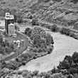
Highlights of the 2013 removals include the Stearns Dam which had blocked steelhead, salmon and trout passage on Oregon's Crooked River for over 100 years, the Whittenton Dam on the Mill River in Massachusetts and the Lassiter Mill Dam on the Uwharrie River in North Carolina.
American Rivers maintains a database of known dam removals since 1912, to which it will add the 51 dams removed in 2013. The current total of dam removals sits at 1,150. Highlighting the recent trend of dam removal is the fact that 850 of these removals have occurred during the past two decades.
The group has also launched an interactive map of dam removals dating back to 1936. Users can browse the map to view the locations of these removals, the river or stream involved and the date of the removals.


.")
.")


.")
.")


.")
.")


.")


.")
.")

.")

.")
Comments